

Draft Prospect Creek Flood Risk Management Study and Plan
We've prepared a draft flood risk management study and plan for the City’s four sub-catchments of Prospect Creek.
Consultation has concluded
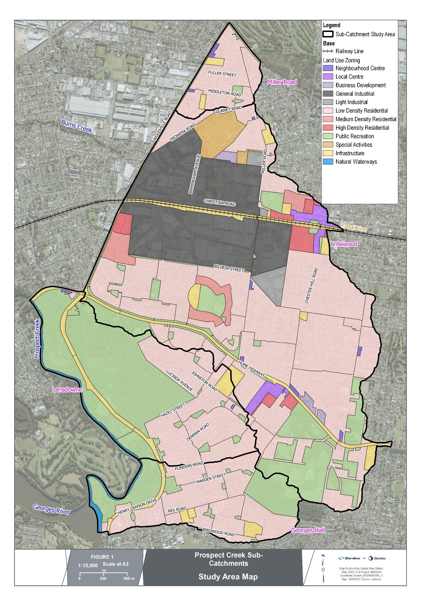
Council is preparing a Catchment Action Plan (CAP) for the four sub-catchments of Prospect Creek. The study area is provided in the map below and is divided into four sub-catchments being:
The objective of the CAP is to:
The following tasks will be undertaken:
In simple terms, a catchment is any area which rain falls on to and then drains to a single point. A catchment can be as small as a roof or as large as the Murray-Darling Basin. What happens in this area determines a catchments water quantity, quality and its behaviour.
Before people started changing the environment, a catchment would have been an area where water collected by the natural landscape. Its hills and mountains define this area and some rainwater would eventually flow to the lowest point, most likely, a creek, river, lake or ocean.
In the present day, the Prospect Creek Sub-catchments have become a mix of leftover natural environments mixed with urban environments (i.e. houses, business and roads). This mix of natural and urban environment is not unique. The challenge is maintaining a healthy catchment.
Healthy catchments can provide:
Natural and urban systems such as rivers, bushland, farms, dams, homes, business, plants, animals and people need to co-exist in a catchment.
Our daily activities affect the health of our catchments. The first step to protect our catchments is a better understanding of our impact on them.

Urban development has had a large and immediate impact on our catchment. The biggest change is an increase in hard surfaces (roofs, roads and pavements) and the resultant reduction in permeability.
This increase in hard surfaces directly causes greater volumes of surface water. As rain that would have normally soaked into the ground will now run off the hard surfaces faster and in greater volume.
As a consequence, flooding which was always a natural occurrence would become more frequent. To combat the flooding, stormwater pit, pipes and channels were constructed to drain additional runoff to the waterways faster.
Yet, larger flows would still flow overland as stormwater network capacity was exceeded. The downside to the earlier stormwater network designs was that the faster and greater water would erode our creeks.
Also, the stormwater network would be become very efficient at moving pollutants like litter, sediment, nutrients so forth, to our waterways which are suffering as a result.


A large proportion of the study area is developed as low density residential and includes Bass Hill and Chester Hill town centres and the Villawood industrial precinct. The undeveloped areas are large open space reserves and include The Crest, Lansdowne Reserve, Amaroo Reserve and Garrison Point Reserve.
Stormwater runoff from the Georges Hall and Lansdowne sub-catchments discharges to Prospect Creek directly, while runoff from the Villawood and Miller Road sub-catchments discharges west to Burns Creek, a tributary of Prospect Creek. Ultimately this runoff flows to the Georges River and along to Botany Bay.
Community consultation is a key component of the study process and we are now seeking feedback from residents, land owners and business operators in the study area.
This is the initial community consultation stage for this project.
Timeline item 1 - complete
Initial stage - community consultation
Wednesday 8 February 2023 to Wednesday 5 April 2023
Timeline item 2 - active
Under review
April - May 2023
Timeline item 3 - incomplete
Option assessment & design
May - September 2023 (expected)
Timeline item 4 - incomplete
Public exhibition of draft CAP
October 2023 (expected)
Residents, property owners and business operators within the study area are invited to share their observations and opinions of the current catchment management for the area including water quality, water balance and stormwater management.
By completing the on-line survey, we will gain a better understand for your preferences for areas of the catchment to be enhanced, and your preferred methods to achieve these enhancements. The survey is hosted by our project partners - Stantec and, we will accepting feedback until 5pm on Wednesday 5 April 2023.
Submissions are now closed. All feedback and comments received will be reviewed and considered.
If you have questions or want to learn more about the project, please contact the Council officers listed below.
| haveyoursay@cbcity.nsw.gov.au | |
| In writing | By post to Mr Matthew Stewart, CEO, City of Canterbury Bankstown PO Box 8, Bankstown NSW 1885 |
The City of Canterbury Bankstown acknowledges the Traditional Custodians of the land, water and skies of Canterbury-Bankstown, the Darug (Darag, Dharug, Daruk, Dharuk) People. We recognise and respect Darug cultural heritage, beliefs and relationship with the land. We acknowledge the First Peoples’ continuing importance to our Canterbury-Bankstown community.
![]()


